
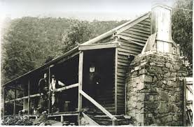
Toombon Village Huts
Known as: Toombon Mine Village, Toombon Huts or Toombon Gold Mining Precinct.
Located along Toombon Creek, east of Thomson Reservoir.
From Erica, follow Thomson Dam Access Road across the dam wall, then take Walhalla Road north towards Aberfeldy. Turn right into Donnellys Creek Road and follow it towards the Toombon historic site near the Toombon Track junction. Park at the signed historic-site access and explore the mine and township remains on foot.
The forest approach is unsealed and includes a 4WD creek-road section. The coordinates below identify the mining precinct rather than a confirmed standing hut.
History
Reef mining in the area began in the 1860s, with the township developing around the workings from about 1870. The Toombon Gold Mining Company was formed in 1881. When the mine closed in 1898, its workings had reached nearly 1,000 ft (about 305 m), with recorded production of 50,844 oz of gold. The 1998 Victorian heritage survey identifies it as the largest gold producer in the Aberfeldy–Donnellys Creek district.
A company formed in 1934 attempted to reopen the mine, but operations ended in 1940. The surviving water-tube boiler belongs to that later phase. The precinct also contains machinery foundations, mullock heaps, building terraces and masonry chimney remains.
Some later restored buildings, including the former Toombon Hotel, were destroyed in the 2013 Aberfeldy bushfires. A subsequent rebuild of a separate Toombon hut has not been independently confirmed.
References
Victorian Goldfields Project, Historic Gold Mining Sites in Gippsland Mining District (1998),
Toombon precinct; Mountain Rivers Tourist Park, The Story of Six Big Rivers (later buildings and 2013 fire).
Mapping Guidance:
GPS (WGS84 assumed): 37.733990°S, 146.404770°E.
UTM: Zone 55, southern hemisphere (grid zone 55H), 447552 mE, 5823532 mN. Approximate precinct reference retained from this profile; not a verified individual hut position.