
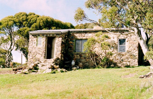
Cleve Cole Memorial Hut
Photo courtesy of David and Bev Steer © 2001.
Known as Cleve Cole Hut or Cleve Cole Memorial Hut
Located on the Camp Valley walking route on Mount Bogong, near the head of Camp Creek.
From Mount Beauty drive approximately 15 km via Tawonga and Mountain Creek Road to Mountain Creek Picnic Area; the final road includes gravel. Park there, ascend Staircase Spur past Bivouac Hut to the summit plateau, then follow the signed Camp Valley route to Cleve Cole Hut.
Allow roughly 12–13 km each way (24–26 km return), with more than 1300 m of ascent on the approach: this is a demanding alpine walk, commonly undertaken overnight.
A 4WD approach to Camp Creek Gap can shorten the Eskdale Spur alternative when legally open, but does not reach the hut. Check current road gates, route conditions and weather; carry navigation and overnight equipment.
Brief History
this hut was built in 1937 for the Ski Club of Victoria, and dedicated to pioneer skier, Cleve Cole. Cleve died on a disastrous ski trip across the high plains with experienced Mick Hull and Howard Michell. Cole was a keen skier and scoutmaster, and built the first Bivouac Hut with Walter Maddison. (The recent version of Bivouac Hut was built by the Victorian Government in 1980).
The genesis of the hut was at a SCV meeting in August 1936, when a committee was formed with Gordon Brown as chair, to raise funds for a memorial hut on Mt Bogong.
The Mt Bogong Club (not related to the NSW Bogongs) was formed in 1965 and took over maintenance of the hut, plus Michell Hut. They extended the hut in 1989 with the addition of the store room on the Eastern side.
More recently, a double decker toilet has been built nearby by the Parks service.
Construction
The hut is unusual in size, outlook and construction, having 15 inch thick stone walls. An early fault near the chimney allowed snow to enter, and major restoration took place just 10 years after construction.
The architect was Malcolm McColl, who also designed accommodation as a "snow specialist" at Hotham, Bogong, Buller and Falls Creek, and was a founding director of Ski Tows Ltd.
There used to be a 65 foot radio mast nearby, which is now buried in the scrub. There were also plans to add another hut nearby, to keep up with the demand for this one, but none are planned now.
Caretakers - The Mt Bogong Club
References
Hueneke Pp170, 186, 233
G. Butler 1996 Pp 67 - 73.
Magnussen P96 - 101
Victorian Ski Yearbook 1937 - McColl design.
Stephenson.
Mapping Guidance;
GPS: approximately 36.75587°S, 147.32724°E.
UTM Zone 55H: 529209 m E, 5932159 m N (WGS84). Approximate VHCHA mapped position.