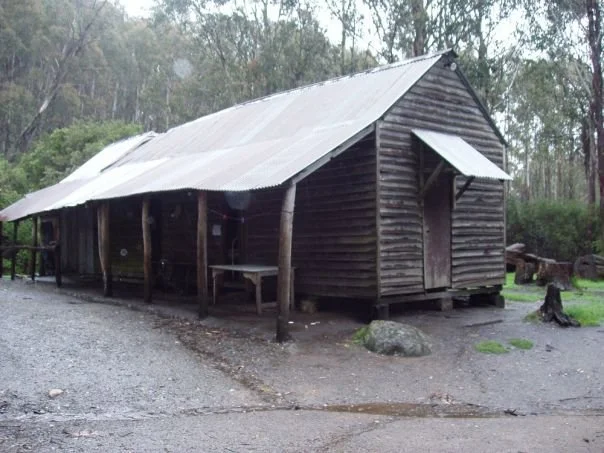
Razorback Huts
Photograph above courtesy of Rooftop Maps © 2003. Lower photograph courtesy of John Mitchell, showing Purcells Hut in 1971.
Known as Razorback Hut, the Razorback Hilton or Purcells Hut.
Located near King Saddle on Mount Stirling.
From Mansfield, follow sealed Mount Buller Road about 30 km to Mirimbah, then gravel Mount Stirling Road about 8 km to Telephone Box Junction. Keep left onto the northern Circuit Road, continue past King Saddle and take the signed Razorback Hut turn-off just before Number 3 Road.
The huts and camping area are about 500 m along this access road. Allow roughly 42–45 km driving from Mansfield and about an hour to the hut. Different sources refer to different junctuions so follow the signed turn-off.
The government visitor guide rates this approach suitable for 2WD in dry weather only. Park at the camping area and walk the short distance to the huts. Vehicle access is seasonally closed over winter, generally June to late October or early November, and closures can be extended.
History
The Purcell family built the original hut in 1953 for stockmen on the annual cattle drives. John Mitchell’s 1971 photograph shows an earlier stage of the complex. Later additions provided further huts, sheds and horseyards, and the site became popular with horse riders and walkers. “Turkey Tom” Purcell is named in earlier accounts; current caretaker arrangements need confirmation.
Construction and use
The complex includes weatherboard and iron-clad buildings. The current government guide describes a main hut with two fireplaces and a separate bunk hut accommodating up to 20 people. Older claims of more than 40 bunks across the complex should not be treated as current capacity but were accurate for their time.
3D imagery
https://my.matterport.com/show/?m=1DNDQjTdSp3
https://my.matterport.com/show/?m=QndVEhHzRDv
References
Explore Outdoors Victoria, Razorback Hut (updated October 2026);
Mansfield Mt Buller visitor information;
Hueneke, pp. 87, 91 and 241.
Mapping Guidance
GPS: approximately 37.10378°S, 146.46414°E.
UTM Zone 55H: 452386 m E, 5893481 m N. Approximate VHCHA mapped complex position, treated as WGS84.