
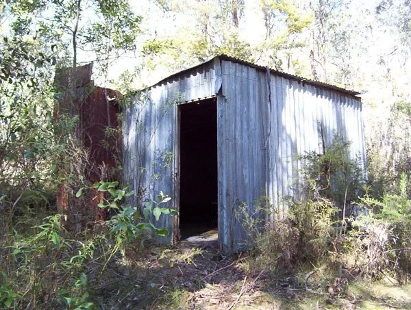
Upper New Place Hut
Known as New Place Hut or Upper New Place Hut.
Located by VHCHA on Williams Road near New Place Creek, in the forest north of Briagolong.
The mapped locality is east/south-east of Licola, not west/north-west as previously stated. One documented regional 4WD approach follows Freestone Creek Road from Briagolong, then Lloyd Knob Track, Blomford Jeep Track and Upper New Place Creek Road.
A Victorian Four Wheel Drive Club report from 2019 describes this route but says the party could not locate the hut ruins. The connection to the photographed hut and the final Williams Road spur need confirmation. The approach changes from sealed road to gravel and rough 4WD tracks; do not assume 2WD access beyond Freestone Creek Road.
History
The builders, construction date and original purpose have not been established.
The earlier generic attribution to grazing, forestry or survey work was not supported by a specific source. A 2019 club report refers to ruins at Upper New Place, but does not confirm the condition or identity of the building photographed here. More history and a recent site report are needed.
Construction
The photograph shows a timber-framed hut clad in corrugated iron, with an iron roof.
Caretakers: Victorian Four Wheel Drive Club.
References
HEMA High Country Victoria map, 1:200,000 shows the named location. Upper New Place Hut and hut-map dataset;
Victorian Four Wheel Drive Club, November 2019 newsletter,
trip report via Lloyd Knob and Blomford Jeep Track;
OpenStreetMap-derived listings for comparison.
Mapping Guide
GPS: provisionally 37.61337°S, 147.04839°E.
UTM Zone 55H: 504271 m E, 5837080 m N. Approximate VHCHA mapped position, treated as WGS84.
Other mapping places Upper New Place about 2 km farther west. Exact hut identity, position and survival remain unconfirmed.