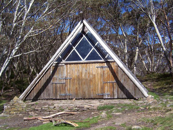
Gantner Hut
Photos courtesy of John Mitchell © 1971. The summer photograph below is by Gary Duncan.
Known as Vallejo Gantner Hut, Gantner Hut or Macalister Springs Hut.
Located at Macalister Springs on the Mount Howitt walking track.
From Licola, follow Tamboritha Road for about 46 km to Arbuckle Junction, then turn left onto Howitt Road and continue about 37 km to the Mount Howitt car park: approximately 83 km in total. The first 22 km from Licola are sealed; the remaining roads are gravel, generally suitable for 2WD vehicles in good, dry conditions when open. Seasonal gates, snow and road damage can prevent access.
From the car park, walk about 4.5–5 km each way to the hut, allowing 9–10 km return.
History
The hut was built in 1970–71 in memory of Vallejo Gantner and opened on 17 April 1971. Born in San Francisco in 1942, Vallejo came to Victoria at the age of 12 and attended Melbourne Grammar School. He loved the mountains and died in a shooting accident at the age of 19. His mother, Neilma Gantner, obtained permission for a memorial hut in the Victorian Alps.
David McGlashan of McGlashan and Everist designed the hut. Two acres were reserved by the Forests Commission for the project in 1971.
Builder Jim Beha worked with assistance from boys from Box Hill High School and Melbourne Grammar School. Stone was carried in an old Land Rover; Reg Bertram and his son Graeme undertook the stonework, with carpentry by Lal Hallewell and Jerry van Poppel.
3D imagery
VHCHA provides a virtual tour: https://my.matterport.com/show/?m=X6DYD3aYNQY
Construction
The distinctive triangular building has a copper roof and stonework. Its exposed alpine setting makes it an important emergency shelter, although walkers should carry their own tent.
References
Hueneke, Huts of the High Country, pp. 50–51 and 236;
Butler, Victorian Alpine Huts, pp. 114–117;
Siseman, p. 94;
Bushwalking Victoria, Mount Howitt walk notes;
VHCHA hut-map dataset.
Mapping Guidance:
GPS: approximately 37.17234°S, 146.67076°E.
UTM Zone 55H: 470772 m E, 5885958 m N. Approximate VHCHA mapped position, treated as WGS84.