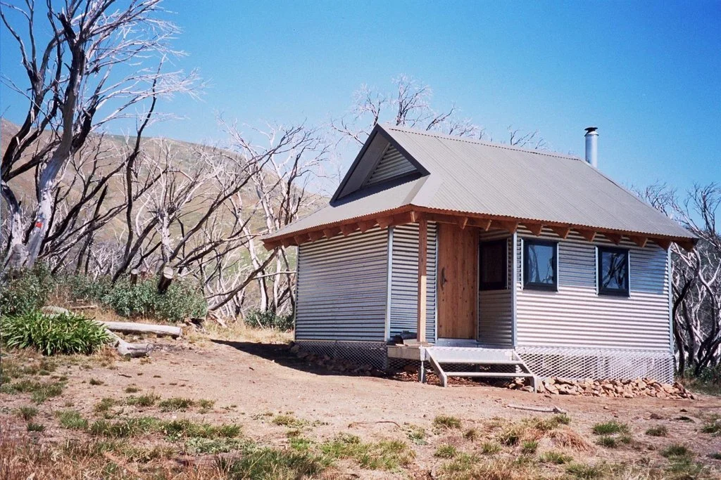
Michell Hut
Known as: Michell Hut sometimes as Mitchell Hut. Michell Hut and Michell Refuge are used interchangeably. It’s named after pioneer skier Howard Michell. (Not Michelle)
Located at: On Eskdale Spur, Mount Bogong.
From Mount Beauty drive approximately 15 km via Tawonga and Mountain Creek Road to Mountain Creek Picnic Area; the final road includes gravel. A capable 4WD may continue to Camp Creek Gap when the permitted tracks are open, subject to current park advice.
From Camp Creek Gap climb the signed Eskdale Spur walking track for about 2.5 km to Michell Hut (5 km return), a steep ascent of roughly 500 m. Starting on foot from Mountain Creek adds approximately 6.5 km each way along the valley track, making the hut walk about 18 km return. There is no vehicle access to the hut itself. Confirm gates, seasonal closures, snow and creek conditions before departure.
History:
The Mt Bogong Club built the original hut in 1967 as a refuge for walkers and skiers, named in memory of Michell.
It was meant to be one of several huts along the “Classic Tour” ski route from Mt Bogong to Mt Hotham. Damage to the environment during construction caused outrage, and the other huts were never built. The Lands Department never finalised the Permissive Occupancy, which made replacing it problematic.
The original hut, is famous for having been made from a commercial Myer garage, a design that offended many conservationists. But the January 2003 bushfires destroyed it.
It was replaced in January 2005 and flown in by helicopter in time for that winter’s ski season. The new hut was designed by Tonique Bolt of Underwood and Bolt, at the same time as the new Federation Hut on Mt Feathertop.
Construction
The original hut was a 14 by 20 ft Myer garage with a small door and no windows. It was fully lined with a wooden floor, the fireplace was outside, and water came from a drum.
The current hut is pre-fab sawn timber frames overlaid with corrugated iron as shown in the photo here.
References:
A 2017 forum post cites Siseman and Brownlie’s Bogong National Park (1986) as saying the original hut was built in 1956.
The Mt Bogong Club, Wikipedia and ExplorOz confirm that the original hut was built in 1967.
Mapping Guidance;
GPS: approximately 36.71967°S, 147.31275°E.
UTM Zone 55H: 527929 m E, 5936179 m N (WGS84). Approximate VHCHA mapped position.