
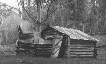
Bindaree Hut
Photo copyright John Mitchell © 1971, showing an earlier timber-and-iron chimney.
Known as Bindaree Hut.
Located beside the upper Howqua River at Bindaree Flat.
From Mansfield, follow sealed Mount Buller Road to Mirimbah, then Stirling Road to Telephone Box Junction and Circuit Road to Bindaree Road. Descend past Bindaree Falls to the hut and river flat. Allow just over two hours from Mansfield; total driving kilometres have not been reliably confirmed.
Beyond Mirimbah the roads are gravel, and Parks Victoria describes the final campsite approach as 4WD access. Use a high-clearance 4WD, check seasonal gates and park at the flat for the short walk to the hut. No river ford is needed from the Circuit Road side.
History
An earlier slab hut existed before January 1926, possibly from about 1914. It has been attributed to Jim Ware, son of grazing lessee John Ware. A photograph dated 1916 shows Jim Barclay outside a hut of this form. Arthur Dale’s relatives attribute another early-1930s hut here to him.
Family evidence attributes the present structure to Harry Norris, Fred Fry, Harry O’Brien and Joe McIlroy in about 1937, funded by the Mansfield Tourist Association for walkers.
Harry Norris built forestry huts and camps, including at Mirimbah. The evidence may indicate three huts, or two with substantial rebuilding; the earliest sequence remains uncertain.
Construction and conservation
The hut has broad-leaved peppermint log walls, sapling roof poles and a corrugated-iron roof. It is a simple building without windows or furniture. A stone chimney replaced the earlier timber-and-iron form in 1986.
After the masonry deteriorated, conservation work restored an iron chimney in December 2016. Further work in February 2018 replaced rotten base logs and repaired the door and chimney framing. VHCHA, Parks Victoria and Mansfield 4WD Club were involved.
Caretakers:
Earlier accounts name Wollangarra staff and students as caretakers; the more recent work is documented by VHCHA.
References
VHCHA, Bindaree Hut;
Parks Victoria, Bindaree Flat Camping Area;
Hueneke, pp. 76 and 231;
Butler 1996, pp. 5–6, and Report II, pp. 50–54;
Stephenson, pp. 137–138 and 145;
Siseman, p. 86 E4;
Chris Stoney, The Howqua Hills Story (1993);
Robert J Norris, personal communication, 28 September 2003.
Mapping Guidance:
GPS: 37.16680°S, 146.54285°E.
UTM Zone 55H: 459413 m E, 5886526 m N. Approximate VHCHA mapped position, treated as WGS84; not field-verified.