
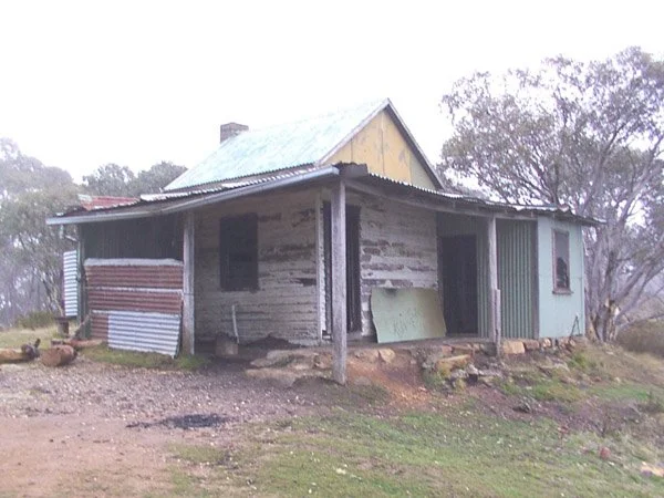
Mt Terrible Fire Tower Hut
Photo courtesy of Ron Dickson © 2004
Known as the Mount Terrible Hut
Located: below the fire tower near the summit of Mount Terrible, south of Jamieson. From Jamieson, take the Mansfield–Woods Point Road towards Kevington, then turn onto Poletti Track north of the village and climb the Mount Terrible Track. Follow the summit route to the hut. The main-road approach is sealed, but the mountain tracks are unsealed, steep and rough: use a capable 4WD or suitable off-road motorcycle in dry conditions. Parking is beside the hut when the tracks are open, with no substantial walk.
History
Originally a 22-meter steel fire tower was erected in early 1962 to replace the original Jamieson Lookout. A corresponding accommodation hut (12ft x 12ft) was built mid-1962 to house fire-watching crews from the CFA and DSE during the summer months.
By 2008, the hut had fallen into significant disrepair and was at risk of being demolished. The Victorian High Country Huts Association (VHCHA) took over as caretakers, performing major restoration work in 2009, including replacing a wall and repairing the fireplace.
Loss and rebuilding (2012–2016): The original hut was destroyed by fire in December 2012. VHCHA reports that a log may have rolled from the fireplace while people were staying there; the cause is not confirmed. A joint rebuilding project involving the land manager, VHCHA, volunteers and sponsors produced a replacement ready by Christmas 2016.
Construction
A weatherboard hut built over a standard timber frame with a hard floor and fireplace.
Caretakers Victorian High Country Huts Association (VHCHA)
References
VHCHA Report
Mapping Guide:
GPS: 37.394833°S, 146.140117°E.
UTM Zone 55H: 423888 m E, 5860979 m N. Approximate ExplorOz position, treated as WGS84; not field-verified.