
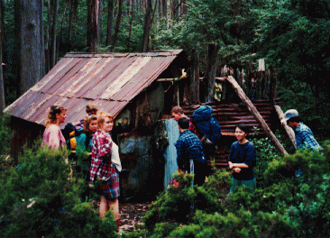
Jan's Hut
The photo shown, is courtesy of the Jans family.
Known as Jans Hut or Staggs Hut.
Located on the eastern side of the Baw Baw Plateau.
From Erica, follow Thomson Valley Road north towards the eastern side of the plateau. Access to Jans Hut is on foot from Thomson Valley Road; there is no vehicle access to the hut.
The approach crosses difficult, partly untracked terrain, so confirm the starting point and route with an experienced local walker before setting out.
A Ben Cruachan Walking Club itinerary lists an 8 km Jans Hut walk; distance depends on the chosen starting point. The Mount Erica car park is another possible approach, but involves a much longer bushwalk.
History
The hut was built by Johan Jans and his son Frederick about 1922. It was razed to the ground in the 1939 fires and rebuilt, standing today.
The Jans family originally came from Denmark to settle in the Warburton area. To quote Mirelle Jans recently (2025):
Fred (Curly) Jans and his nephew Norm (Bluey) Jans rebuilt their Hut on Mt Baw Baw after it burned down in the 1939 Bushfires along with 600 + head of their cattle.
The Hut was rebuilt by hand with true bushman skills after they pack-horsed the materials in.
Dad (Norm) enlisted for Military Service for WW2 in April 1940. While Norm was deployed overseas, Fred Jans became gravely ill with cancer. Family told Mum (Freida Jans) that Fred hung on for dad to get back home. In August 1942, Norm arrived home, Fred passed away in December 1942.
This remote Hut on Mt Baw Baw is a testament to the memory of the grit and determination of getting things done by these two men in the toughest of times.
On the 1st of November this year (2025), Fred and Norms' descendants, along with family friends, got together and walked to the hut to celebrate the history of 'Jans Hut'.
Mirelle Jans
Construction and Restoration
In 2011 the fireplace and chimney reconstruction was undertaken, plus other restoration.
In March 2022: repairs were made after a tree badly damaged the hut in June 2021.
Caretakers - Jans Family and friends
References
Craig Copland (a relative) - pers comm.
Gary Duncan and Robin Rishworth
Mapping Guidance:
GPS (WGS84): 37.804450°S, 146.309083°E.
UTM: Zone 55, southern hemisphere (grid zone 55H), 439178 mE, 5815657 mN. Mapped hut position (ExplorOz).