
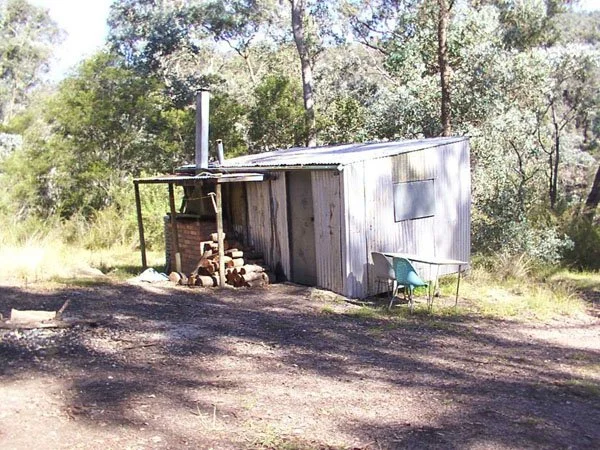
Wallers Huts
Known as Owen Waller Hut or Waller’s Huts.
Located beside the Wentworth River near the junction of Friday Spur Track and Storer Track (also mapped as Storers Track), just above a river ford.
From Dargo the regional approach is south towards Tabberabbera Road, then north on Gidley Track and east on Storer Track to the hut. Confirm the connecting turn-offs on a current topographic map. The main approach starts on sealed road, then uses gravel roads and steep, stony 4WD tracks.
NOTE that the descent towards the river becomes increasingly steep. A capable high-clearance 4WD is required for the final tracks. The total drive distance, gate status and a reliable 2WD parking point have not been verified, so no short walking alternative is promised.
History
Owen Waller was introduced to the area by his friend Bluey Ellis, the shire dog trapper, in about 1968.
Owen noted that the area held a good number of "wild" cattle and thought there was an opportunity to remove and sell them over a period of time as well as grazing his own cattle. He took over what was known then as a Crown cattle lease over a large area including that surrounding the hut.
At about this time, Bob Carruthers started bringing his family up to the "Wentworth", accommodation at this stage was under canvas and after spending a couple of bitterly cold winters with snow on Morris Peak he suggested to Owen that we build a more permanent structure that might last a few years.
When we got back to Melbourne Bob drew up some plans and began construction of the hut on our garage floor at home. The frame is all second-hand Oregon (many a night & day spent pulling nails), the floor was our old garage door from home, the second-hand iron came from Treasure's abandoned mine up Teapot Creek, and all other timber, was second-hand sourced from far and wide.
The hut was then transported and assembled over a 12–18-month period in 1969 and 1970 with the assistance of members of the Carruthers and Waller families. The track in those days was something to behold and getting out was always a lottery. The hut lasted well beyond expectations largely due to the fact that it had never. been locked, and a number of people have continued to maintain and look after it over the years.
We have always kept a visitors’ book in the hut with an incredible number of people from all corners of the world visiting over thirty something years. I am fortunate enough to be able to take my own family to the Wentworth and hope this will continue for many years.
Notes provided by Gary Carruthers, December 2003.
The huts today are obviously well used and maintained, containing all creature comforts including cooking utensils!
Construction
Sawn timber structural work, with wooden floor and iron walls. Corrugated iron skillion roof. Brick fireplace and iron chimney.
Caretakers - there are some but who?
References
Ron Dickson – personal communication.
Gary Carruthers – personal communication.
Mapping Guidance:
GPS: 37.497467°S, 147.391717°E.
UTM: Zone 55H, 534625 m E, 5849868 m N. Approximate main hut position (ExplorOz place 244838); source datum unstated, treated as WGS84.
The VHCHA pin is about 100 m west.